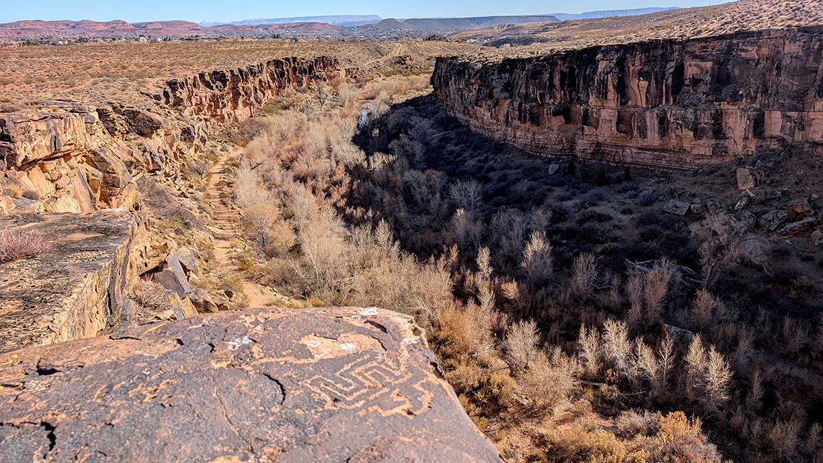
Sunday Hike - Tempi'po'op Trail

Nestled in the rugged red rock landscape of southwestern Utah lies a hidden gem of a hiking trail that offers both stunning natural beauty and a fascinating glimpse into ancient history. The Tempi'po'op Trail, whose name comes from the Southern Paiute language and means "rock writing," lives up to its name by featuring remarkable petroglyphs left behind by indigenous peoples who called this area home for thousands of years.
The trail stretches approximately 5.8 miles as an out-and-back journey, though hikers can easily customize their adventure by turning around at any point. This flexibility makes it an appealing option for both casual wanderers and dedicated hiking enthusiasts. The path winds along the edge of the Santa Clara Cliffs, providing breathtaking panoramic views that showcase the dramatic landscape of Utah's Color Country.
As you begin your journey, the trail gradually climbs up onto the plateau, where the vista opens up to reveal sweeping views of the surrounding valley. The sight of Snow Canyon State Park's stunning red and white sandstone cliffs serves as a constant companion to the west, while the growing communities of Santa Clara and Ivins stretch out below, their buildings appearing almost toy-like against the vast desert landscape.
The area's human history runs deep, with archaeological evidence suggesting that indigenous peoples, including the Southern Paiute and their ancestors, inhabited this region for at least 10,000 years. The petroglyphs visible along the trail offer a tangible connection to these ancient inhabitants. These rock art panels feature various designs, from bighorn sheep and human figures to abstract geometric patterns, each telling a story of the people who once called this land home.
The Southern Paiute, who continue to maintain strong cultural ties to this region, were expert desert agriculturalists who developed sophisticated techniques for surviving in this challenging environment. They created complex irrigation systems to cultivate crops such as corn, beans, and squash, while also gathering wild plants and hunting small game. The trail you walk today likely follows ancient paths used by these indigenous peoples as they moved between seasonal camps and gathering sites.
The trail's elevation provides an excellent vantage point for understanding how these early inhabitants would have used the landscape. From this height, you can see how the Santa Clara River carved its path through the valley below, creating the fertile bottomlands that supported indigenous agriculture. The various geological features visible from the trail would have served as important landmarks for navigation and likely held spiritual significance for the native peoples.
As you hike along the plateau's edge, the landscape tells its own geological story. The dramatic cliffs are composed of layers of sandstone and limestone deposited over millions of years when this area was alternately covered by ancient seas and vast desert dunes. The rich red color comes from iron oxide, while the whiter layers represent different environmental conditions during their formation.
The plant life along the trail offers another window into the region's natural history. Desert-adapted species like Utah juniper, pinyon pine, and various species of sage and yucca dot the landscape. These plants have evolved to thrive in this arid environment and were crucial resources for indigenous peoples, providing food, medicine, and materials for tools and shelter.
Wildlife enthusiasts might spot desert-adapted animals such as lizards, rabbits, and various bird species. During cooler months, you might even glimpse desert bighorn sheep, whose ancestors feature prominently in many of the area's petroglyph panels. Dawn and dusk are particularly good times for wildlife viewing, when animals are most active and the dramatic lighting creates perfect conditions for photography.
The trail's location offers year-round hiking opportunities, though summer months can be extremely hot, making early morning or late afternoon the best times to visit during the warmer seasons. Spring and fall provide ideal hiking conditions, with moderate temperatures and the possibility of desert wildflower displays after winter rains. Winter hiking can be equally rewarding, with the possibility of seeing the surrounding peaks dusted with snow while enjoying mild temperatures on the trail.
The Tempi'po'op Trail serves as an important reminder of our responsibility to preserve both natural and cultural resources. Visitors should remember to practice Leave No Trace principles and show proper respect for the petroglyphs by observing them from a distance and never touching or marking the rock art, as the oils from human hands can damage these irreplaceable cultural treasures.
The trail's accessibility and rich rewards make it a must-visit destination for anyone interested in experiencing the unique combination of natural beauty and cultural history that southwestern Utah has to offer. Whether you're a serious hiker looking for a half-day adventure or a casual walker interested in connecting with the past, the Tempi'po'op Trail provides an unforgettable experience.
To reach the trailhead, follow Old Highway 91 through Santa Clara, Utah. Turn onto Graveyard Wash Road, and you'll see the parking area for the Tempi'po'op trailhead. The parking area is well-marked and includes an informational kiosk with a trail map and important guidelines for visitors. The road is easily accessible by any vehicle. Remember to bring plenty of water, sun protection, and appropriate footwear for your journey along this remarkable trail that bridges the past and present of Utah's desert landscape.

